
You Should Know About The Famous Ottoman Cartographer Piri Reis
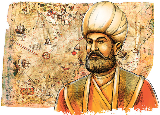
Hacı Ahmed Muhiddin Piri, known as Piri Reis was an admiral in the great Ottoman Imperial navy and the man whose world map is the oldest known Turkish atlas which shows the New World. This world map is also the oldest map of American still in existence.
Piri Reis’ Identity in the Ottoman Archives:
Many years passed by and very little was known about the identity of Piri Reis until the Ottoman Archives were found. The Information gathered from Ottoman Archives shows that Piri Reis’s full name is Hacı Ahmed Muhiddin Piri and he was born in either Gelibolu on the European part of the Ottoman Empire or in Karaman, his father’s birth place, which is located in central Anatolia. His exact date of birth is not known as of yet, but historians has estimated it to be somewhere between 1465-1470.
Following the Foot Steps
Piri Rei’s paternal uncle, Kemal Reis, was a renowned seafarer and corsair. In 1495 he became admiral of the Imperial Navy. Following the footsteps of his uncle in 1481, Piri Reis became a privateer for the Imperial Navy, where he participated in several wars of the Ottoman Empire along with his uncle. These Included the 1499 ‘Battle of Zonchio’ and the 1500 ‘Battle of Modon’. Things took a momentous turn when Kemal Reis died in 1511 due to a storm that wrecked his ship in the Mediterranean Sea, while heading for Egypt. This lead Piri Reis to return back to Gelibolu and focus on navigation studies.

Christopher Columbus and Various Other Maps
While returning back to Gelibolu and focusing on navigation studies, Piri Reis compiled his first world map in Muharram 919 (9 March-7 April 1513). His first world map is centered on Sahara at the latitude of Tropic of Cancer. Today only around one-third of the map exists and the remaining is yet to be found. According to the found archives, Piri Reis have claimed to use 20 source maps which includes 8 Ptolemaic, 4 Portuguese, and one Arabic map. It also includes a map by Christopher Columbus. The map was first obtained by Kemal Reis in 1501 after capturing seven ships off the coast of Valencia in Spain. His first world map was discovered in 1929 at the Topkapi Palace in Istanbul by a German theologian Gustav Adolf Deissmann. This map was also presented to Sultan Selim I in Cairo in the year 1517. Interestingly, this is the first Ottoman map showing the existence of America and the New World. This map includes parts of Europe, the west coast of Africa, eastern, central and south America, the Atlantic islands, and the ocean. South America is given a great deal of detail. The maps format was based on that of a portolan chart, which was a very common format for maps at that time. In the map latitude and longitude grids were replaced by compass roses which were placed at key points radiating azimuths from them.
Kitāb-ı Baḥrīye,the Book of Navigation
Perhaps the most famous pre-modern book of navigation,Kitāb-ıBaḥrīyenot only contains detailed information on navigation, but also has accurate charts describing the cities and important ports located near the Mediterranean Sea. The major ports, bays, gulfs, capes, peninsulas, islands, straits and safe anchorages of the Mediterranean Sea are explained in great detail. The book is also rich on matters such as navigation techniques and navigation-related information on astronomy. It also includes information about the local people of each country and city, and various aspects regarding their culture.Kitāb-ıBaḥrīyewas originally written somewhere between 1511-1521 but it was revised with additional information and detailed crafted charts between 1524 and 1525. The book was given as a gift to Sultan Suleiman the Magnificent.
While traveling around the Mediterranean Sea with his uncle Kemal Reis, Piri Reis drew these charts. The revised version of the book contains 434 pages, including 290 maps.Kitāb-ıBaḥrīyecontainstwo main sections, the first section consist of detailed information on matters such as types of storms, techniques of using a compass, portolan charts with detailed information on ports and coastlines, methods of finding direction using the stars, characteristics of the major oceans and the lands around them. It also mentions discoveries in the New World by Christopher Columbus and Vasco da Gama. Portolan charts and cruise guides is what comprises of the second section but with great detail, each of the topics mentioned contains a map of an island or a coastline.

The Death Sentence
Piri Reis mysteriously disappeared after 1528, just to re-emerge as commander of the Ottoman Suez fleet. The failure at Hormuz and the accusations surrounding it, led to his death sentence, commanded by Sultan Suleiman the Magnificent. His execution took place in Cairo. Piri Reis’s mortal soul may have left this world behind but his work has made him an immortal part of the world’s history.
This article was written by Soniya Shah Noor
References
Piri Reis by Svat Soucek – The Famous People – Muslim Heritage – Steven Dutch, Natural and Applied Sciences, University of Wisconsin – Green Bay
- Sincere Prayer in Islam – Unlocking the Secrets - January 15, 2025
- Science & Religion: A Harmonious Relationship? - December 27, 2024
- The Benefits and Importance of Tahajjud - December 27, 2024


